SP in Action: East Portland 1948
Copyright 2017 by Jim
Lancaster
Except where noted, photos are from the Jim Scott and Jim Lancaster Collections
Except where noted, photos are from the Jim Scott and Jim Lancaster Collections
Southern Pacific 2-8-0 on a freight in yards at Portland, Oregon (Source: Wikipedia)
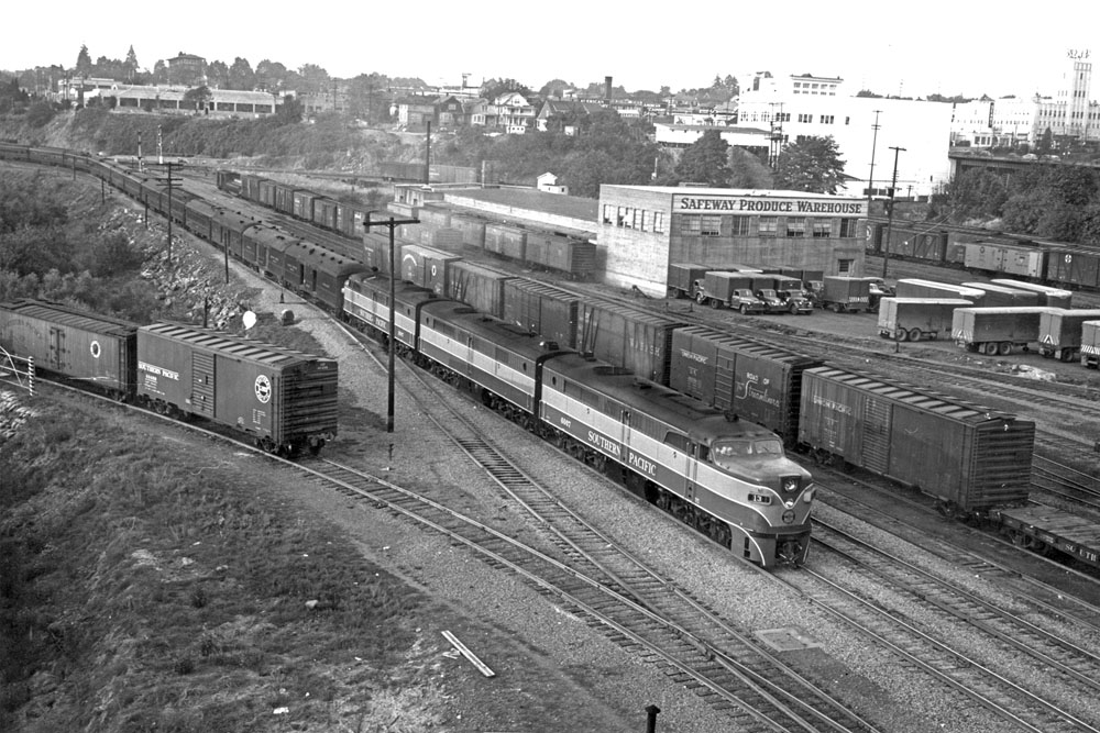
The photo above, showing an eastbound SP freight train passing the Safeway Produce Warehouse in East Portland, Oregon in 1952, is copied from https://upload.wikimedia.org/wikipedia/commons/2/22/USA_019_SP_Portland_Ore._2.jpg. The photo, credited to Ben Brooksbank, will subsequently be referred to simply as the 1952 Photo. The link to the photo was first posted in August 2017 to several Yahoo email groups, including the Southern Pacific, the Steam Era Freight Car and the Citrus Industry Modeling groups.
The following explanation was subsequently posted on one of the Yahoo email groups:
“The photo was made from the Burnside Street Bridge. The SP freight house is behind the photographer along with a large open team track area served by the SP and UP (OWR&N). The train is traveling on what is nominally called East First Street on Portland city maps. Clearly, it was not really a street for auto traffic. One block to the east, the OWR&N had street trackage on East Second Street serving a number of industries and warehouses. Another block east was East Third Street, similarly served by the SP&S with a small freight house and team track area of its own between East Third and East Fourth. You can see the UP's passenger line east at the bottom of the hill (top of the photo).” (Source: Todd Sullivan)
In later posts the large white building in the upper right corner was identified as the Northwestern Ice and Cold Storage Co.'s Union Avenue facility built in 1927.
More Photos of East Portland
October 1948
October 1948
In my own railroad files I subsequently found some photos taken from the same location in East Portland as the 1952 Photo, but dating from October 1948. It’s most likely that these photos originally came from the Jim Scott Collection. Other photos from the Jim Scott Collection are in the article “SP in Action: A North–South Photo Album,” SPH&TS TRAINLINE, No. 14, June 1986, page 5.
Jim Scott lived in Nortbrook, IL and passed away in 2011. I do not believe he was the photographer. There is some evidence that the original photographer’s initials were “I Mc K” or “J Mc K.” If those initials look familiar please let me know.
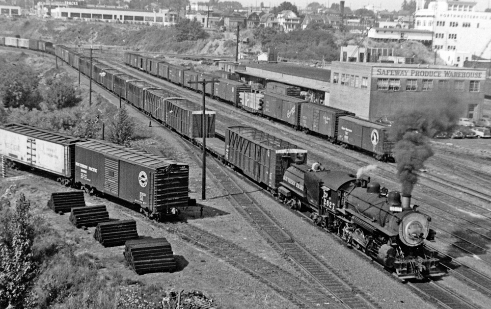
East Portland 1948 Photo 1 (Jim Scott and
Jim Lancaster Collections)
(For a higher
resolution version of this photo, Click Here.)
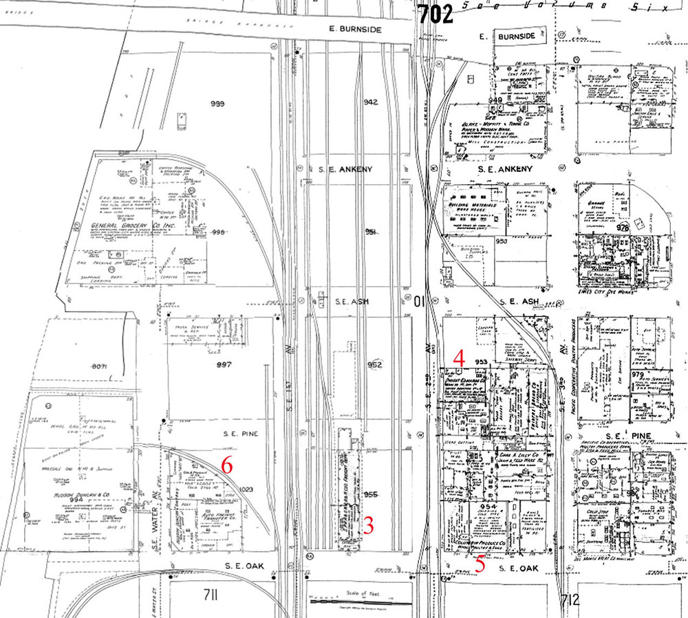
This photo appears to have been taken from the same location on the Burnside Bridge as the 1952 Photo. It shows SP Train 13, pulled by three Alco units numbered SP 6007. The area of East Portland shown in the photo is covered in this composite of two 1950 Sanborn Fire Insurance maps:
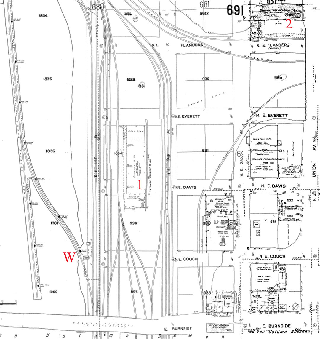
There are two numbered locations on the map: the Safeway Produce Warehouse in the center (#1) and Northwestern Ice and Cold Storage in the upper right corner (#2). Both of these locations are visible on the right side of the 1948 Photo 1 but are more prominent in the next photo.
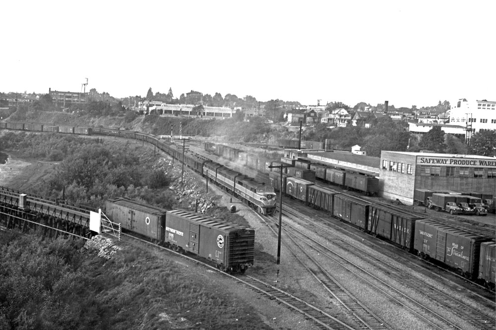
East Portland 1948 Photo 2 (Jim Scott and
Jim Lancaster Collections)
(For a higher
resolution version of this photo, Click Here.)
The curving track in the lower left of each of the above photos originally led to the SP lumber loading wharf (W on the Sanborn map, above). The wharf was evidently built sometime between 1909 and 1924. It does not appear on a 1909 Sanborn map but does appear on a 1924 map. The track and wharf on the 1924 map appear identical to what is on the 1950 map posted here.
An issue of the San Bernardino Sun newspaper dated July 4, 1940 referenced the wharf under the headline "Three [Die] as Fires Sweep Tinder-Dry Pacific Northwest." A long article about fires in Oregon, Washington and British Columbia ended with "Flames struck at Portland, too, destroying a 1,500 foot Southern Pacific railroad lumber loading wharf and 11 railroad cars piled with lumber. Superintendent E. L. King estimated damage from the fire at $65,000. Its cause has not been determined."
Either SP rebuilt the wharf after the 1940 fire or the 1950 map simply copied the 1924 map without correcting the drawing of the wharf. That's a somewhat common occurrence on Sanborn maps.
Train 13 is now a little closer to the photographer in 1948 Photo 2. Interestingly, the unknown original photographer identified the photos as "Cascade Train 12" but that's an incorrect train number. The photos clearly show #13, which would be the Beaver. The three head end cars and the chair cars match the Beaver’s consist for that time frame. But SP passenger car expert Don Munger has looked at the consist and found two diners and a lounge, typical of the Cascade consist, whereas the Beaver had only one diner. In addition, he says the almost-new Alcos were only assigned to the heavyweight Cascade and never to the Beaver.
Don says the Cascade and Beaver were combined twice in 1948 - first in June during the Vanport flood, and again in October. He believes the photo actually shows one of the combined trains running on #13's schedule.
Fortunately, after taking the first two photos, the photographer walked to the other side of the Burnside Bridge and pointed his camera in the opposite direction.
East Portland 1948 Photo 3 (Jim Scott and
Jim Lancaster Collections)
(For a higher
resolution version of this photo, Click Here.)
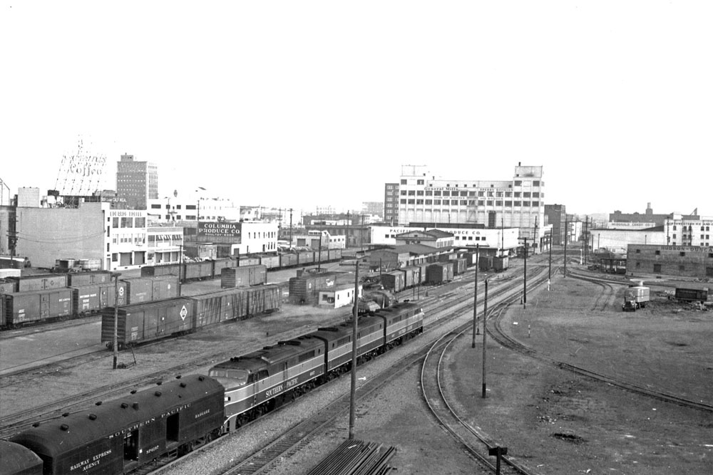
1948 Photo 3 shows the “open team track area served by the SP and UP (OWR&N)” referred to by Todd Sullivan in the second paragraph of this page. The SP freight house is in the center of the photo (#3 on the following 1950 Sanborn map). On the left, beyond the string of reefers, are the Edwards Coffee Company, with the large sign on the roof (#4), and the Columbia Produce Company (#5). Partially visible on the far right, along a curved siding, is the Hudson Duncan Company (#6).
Just beyond the freight house is the Pacific Fruit and Produce Company (#7 on the next 1950 Sanborn map) and beyond that, the large white building is General Mills Sperry (Flour) Division (#8). To the right is another Northwestern Ice and Cold Storage facility (#9). On the Sanborn map there is another Northwestern Ice and Cold Storage facility but in the photo the building signage says McDonald Candy Company.
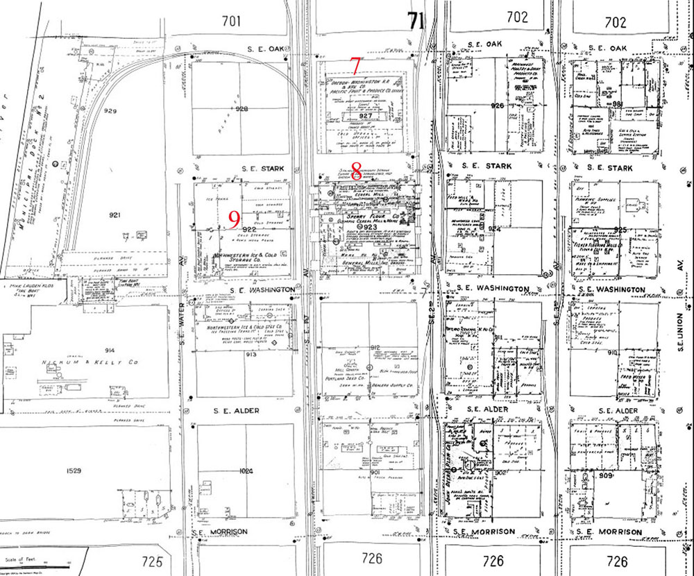
(For higher resolution versions of the last two Sanborn maps, Click Here or Click Here.)
Page Created 9/6/17
Last Update 9/8/17
Last Update 9/8/17