|
Historic Packing Houses and Other Industrial Structures Virtual Tour
of Tustin Copyright 2002, 2006, 2009, 2011, 2013 by James E. Lancaster Notice:The images - photographs, drawings, maps and track diagrams - presented in this web site are the property of the respective contributors and may not be used for any purpose without permission. For more information see Photo Credits and Restrictions. The web site contains a large number of images. Some are displayed inline with the text. However, to control the loading time, the remaining images are viewed by clicking on the related link, e.g., (Photo-JL), (Drawing-HH), etc. Please note that the images that open via these links appear in a separate web browser window. Tustin (ATSF, SP) This virtual tour of past and present packing houses in Orange County begins in Tustin, CA where I have lived for more almost 30 years. Unfortunately the packing houses in Tustin were torn down many years before we moved here so I have no photographs of my own. Tustin was at the east end of the Southern Pacific's Tustin Branch. The branch left the SP's Santa Ana Branch in Anaheim, went east to Villa Park, then continued south across Santiago Creek and through the eastern part of Orange to Tustin. At one time there were packing houses at Villa Park, McPherson (where the track crossed Chapman Ave), El Modena (where the track crossed La Veta) and Tustin. I have photographed parts of a large aerial photo of
Tustin taken in the 1940s that hangs on the wall of the Tustin Area
Historical Society. Figure 1, looking from west to east,
shows the Tustin Hills Citrus Association. 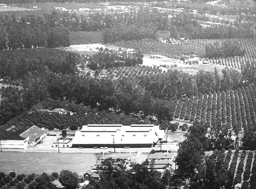 Figure 1. Tustin Area Historical Society Photo It was located on the SP Tustin Branch near the current intersection of Irvine Blvd and Newport Avenue, just east of Holt Avenue. 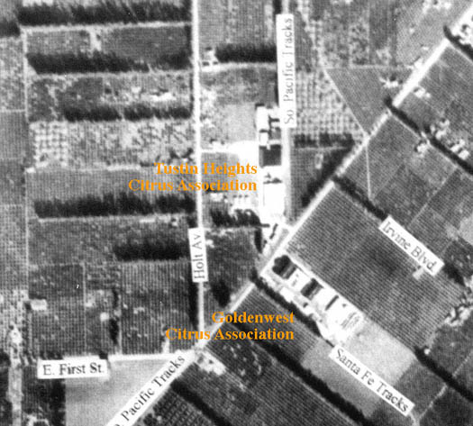 Figure 2. Tustin Area Historical Society Photo This area is now full of commercial buildings and apartment houses, and is surrounded by urban sprawl that began in the 1950s. Here are two close-up views of the packing house complex: one of the south building and one of the north building (Figures 3 and 4). The latter had large Sunkist signs painted on the south and west sides. 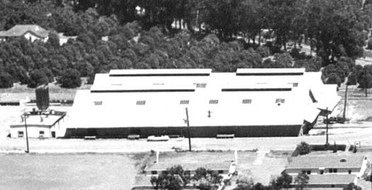 Figure 3. Tustin Area Historical Society Photo 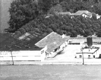 Figure 4. Tustin Area Historical Society Photo About a block away as the crow flies, but miles apart by railroad distance, was the Goldenwest Citrus Association located on Newport Avenue (see previous aerial photo) at the end of a Santa Fe spur that left the mainline at Venta. Figure 5, looking slighty southeast, shows the Goldenwest Citrus
Association packing house complex surrounded mostly by orange groves. 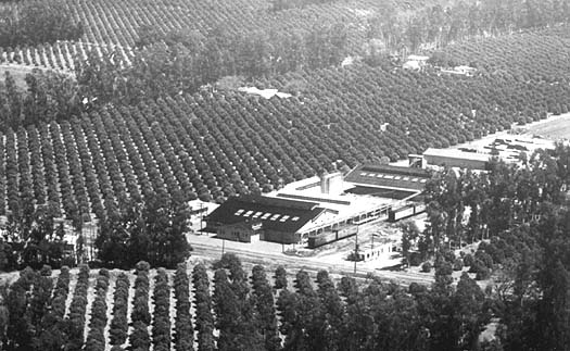 Figure 5. Tustin Area Historical Society Photo This area is now a typical Southern California strip mall anchored by a Ralphs Market. Irvine Blvd now runs along what was the northeast side of the packing house. A close-up view (Figure 6) provides a better look at the packing house and the two Santa Fe sidings, one with at least four refrigerator cars (reefers) waiting to be loaded. There is also a Sunkist sign on the front of this packing house. 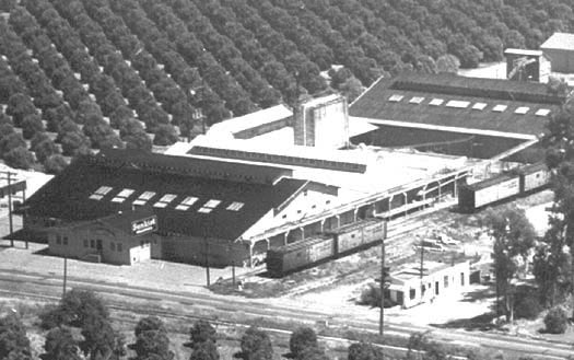 Figure 6. Tustin Area Historical Society Photo The Tustin Area Historical Society
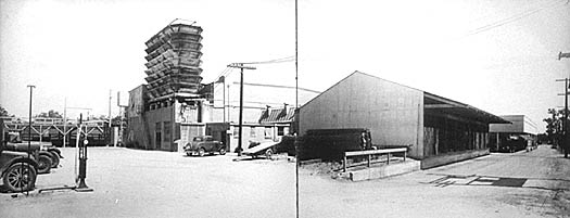
has a number of old photos taken in and around the Tustin packing
houses. These two samples (Figures 7 and 8) were taken on site in the 1940s showing some
of the typical structures.
Figure 9 shows a panoramic view based on the two
previous photos laid side-by-side.
Figure 10, from the 1930s, shows a fleet of
Sunkist trucks loaded with crates of oranges. 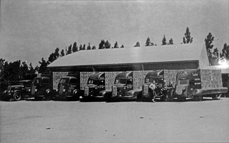 Figure 10. Tustin Area Historical Society Photo Note the unusual fenders and cowling over the cabs on the four trucks on the right (plus the unusual cab on the truck at the far right). The extra sheet metal over the wheels and the cabs enabled the trucks to drive through an orange grove and push branches aside rather than breaking them off by getting caught on the truck. On the side of the truck at the far right it says:
Sunkist
TUSTIN HILLS CITRUS ASSOCIATION Some tractors were similarly equipped for orchard service as shown in Figures 10a and 10b. 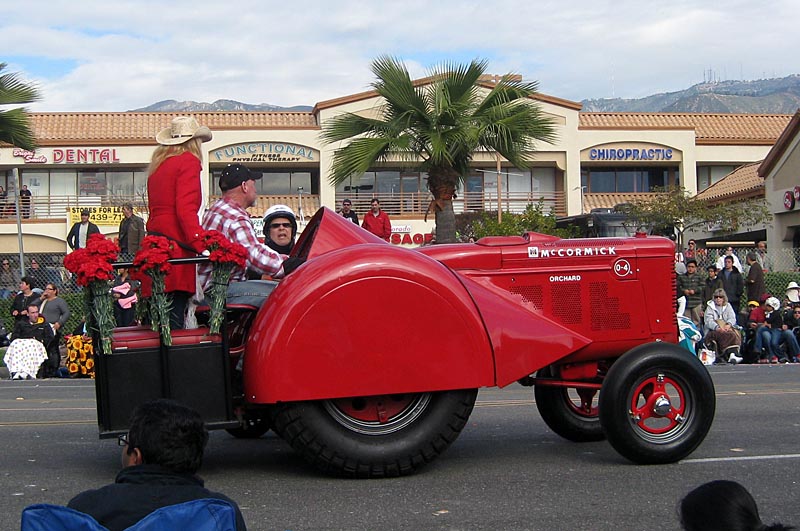 Figure 10a. Vintage McCormick orchard tractor in the 2013 Rose Parade. Jim Lancaster Photo. 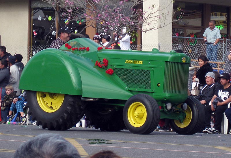 Figure 10b. Vintage John Deere orchard tractor in the 2013 Rose Parade. Jim Lancaster Photo. Bill Rupp has provided a copy of page 100 of a 1952 AAA map showing a part of Orange, El Modena and Tustin.
As of 2011 it
was still possible to walk the former right-of-way from La Veta Ave,
just north of El Modena Station on the map, to Fairhaven Ave.
Warren Ave in Tustin. The
location of El Modena Station and the David Hewes packing house was
still visible - a wide, weed- From Fairhaven Ave. south to Warren Ave. in Tustin the former ROW is now a maintained walking path. The 1952 map also shows the Santa Fe spur that served Tustin. It left the main line at Venta and ran NE to Browing where it split to go to Tustin and Irvine. The last vestige of the spur was removed when Interstate 5 was widened through Orange County in the early 1990s. For more information on the Venta spur, see the Irvine section of the packing house web site. When
the Tustin Branch reached Newport Ave. it turned SW and ran along the
NW side of the street to Laguna Avenue (now El Camino Real).
A third Tustin packing house, the Santa Ana-Tustin Mutual Citrus Assn,
was located along
this section of the branch south of Main Street.
Bill Messecar located
a photo of the Santa Ana-Tustin Mutual Citrus
Assn packing house in the archives of First American
Title
Insurance Company in Santa Ana.
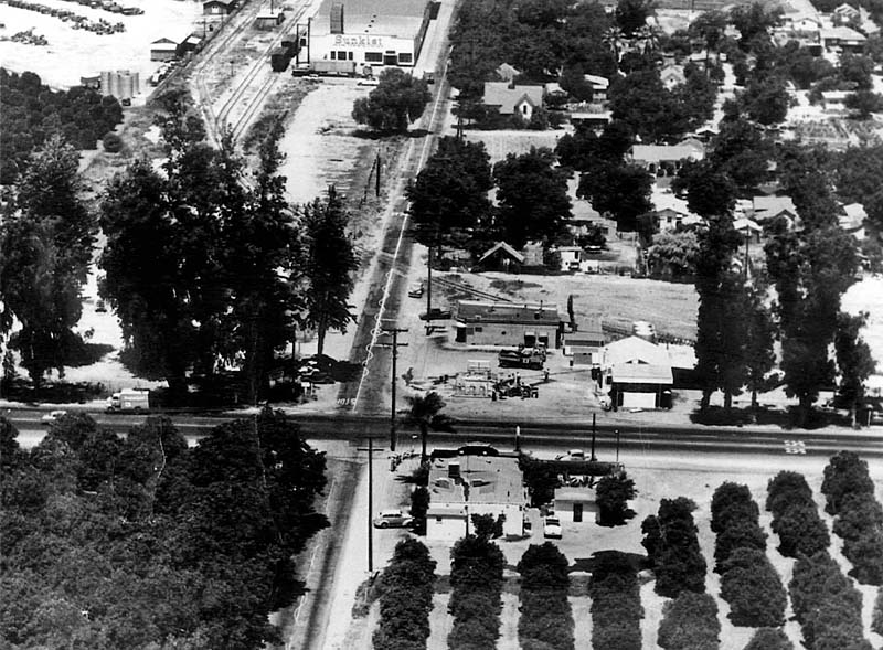
 Figure 11. First American Title Insurance Company Photo The street in the photo above is Newport Avenue
looking NE. The Tustin Branch ran behind the packing house. Steve Donaldson helped pinpoint the location: "I have an SP SBE drawing showing the building at roughly between San Juan and Walnut Streets." Steve also provided the photo below showing the intersection of Newport Ave and US 101, the main highway between Los Angeles and San Diego.
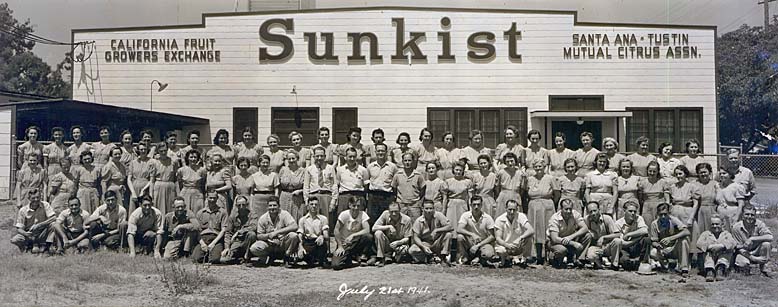
The photo was probably taken in the 1940s. The Santa Ana-Tustin Mutual packing house is at the top. The street running from top to bottom is Newport Ave with US 101 (today's El Camino Real) running left to right. The Tustin Branch ran behind the packing house then curved across Newport Ave to an oil dealer. The branch ended behind the trees at the right of the photo. Cary Wilson provided the following photo of the Santa Ana Tustin Mutual packing house employees from July 1941. Cary's mother and uncle are in the photo.
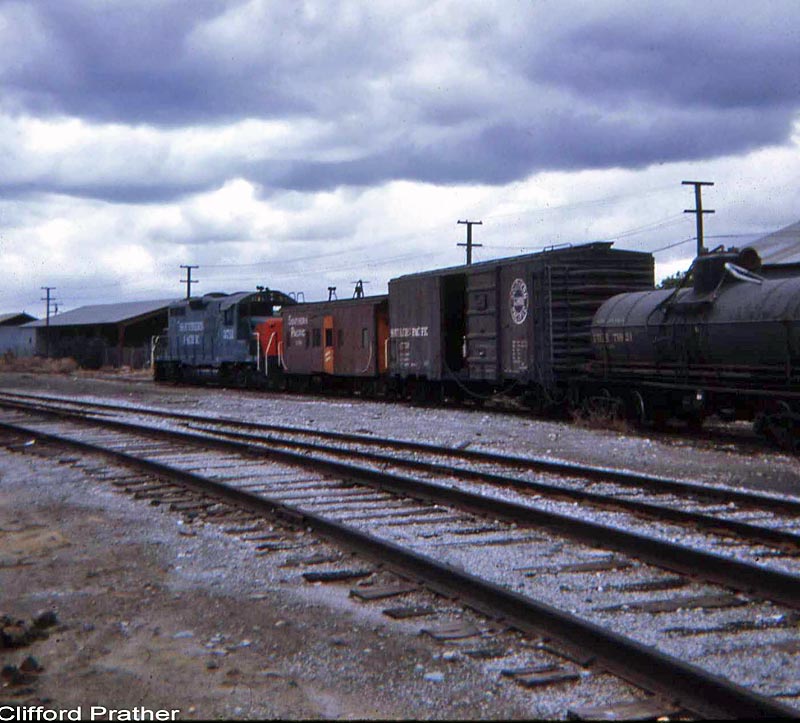
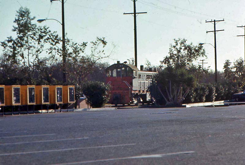
Figure 16 was taken from the Larwin Square parking lot and shows an Alco S6 on the track that paralled Newport Avenue.
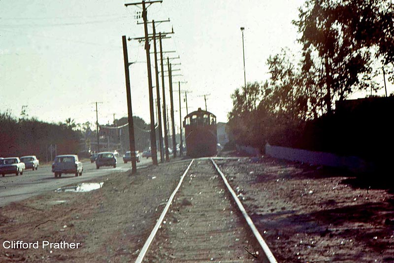
The
SP Tustin Branch was severed at Santiago Creek in the spring of 1969
when a bridge was washed out. The section from Santiago Creek to Tustin
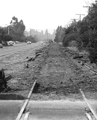
was not used again and was torn up in the late 1970s. Lee Gustavson photographed the tracks behind the Santa Ana Tustin Mutual packing house in July 1969, after the Tustin Branch had been severed by the flooding at Santiago Creek. 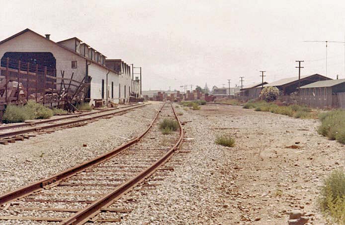 Figure 17. Lee Gustafson Photo Finally, Cliff Prather photographed the salvage work along Esplanade north of 17th Street in January 1978.
Last Update: 4/15/13 To tour other Orange County cities, or other counties, return to the Virtual Tour of Orange County Page. Return to the Historic Packing Houses and Other Industrial Structures in Southern California Home Page. |


 Starting from the top of the map it's possible
to follow the Tustin
Branch south from just below the Santiago Creek bridge, between Orange
and El Modena, past El Modena Station and into Tustin.
Starting from the top of the map it's possible
to follow the Tustin
Branch south from just below the Santiago Creek bridge, between Orange
and El Modena, past El Modena Station and into Tustin.